
Download World Atlas – Learn Geography, Country Maps & Capitals
World Atlas is an educational desktop application designed to enhance geographic knowledge through interactive world maps, country-specific details, and in-depth atlases. It serves as a valuable learning tool for students, teachers, and geography enthusiasts seeking to improve their understanding of global regions, national borders, capitals, and cultural geography. The software provides free access to detailed maps of Europe, the USA, Canada, and other regions, making it ideal for classroom use and self-paced study.
With its focus on visual learning and interactive engagement, it supports both casual learners and structured educational environments. The app is accessible across multiple platforms, offering consistent performance on Windows, Mac, and Linux systems. While the developer did not provide additional system requirements, the application’s lightweight footprint of 12.5 MB suggests efficient resource usage.
The tool is particularly useful for anyone aiming to build or refresh their world map knowledge in a fun and engaging way.
Key Features & Capabilities
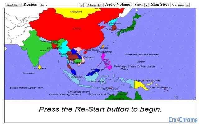
- Interactive World Maps – Users can explore detailed, zoomable maps of the world, with country boundaries clearly defined. This feature enables visual recognition of geopolitical regions and helps reinforce spatial awareness.
- Country-Specific Information – Each country displays key data such as capital cities, population, official languages, and geographic coordinates. This supports deeper learning beyond simple map recognition.
- Regional Map Collections – The software includes free downloadable maps of Europe, the USA, Canada, and other major regions, making it suitable for targeted study sessions or lesson planning.
- Map Quiz Functionality – Built-in quiz mode allows users to test their knowledge of country locations, capitals, and borders, enhancing retention through gamified learning.
- Ad-Supported Model – The application is free to use but includes advertisements, which may affect the user experience during extended sessions.
The software’s interactive map features allow users to click on countries to access instant information, supporting both independent study and classroom demonstrations. Teachers can use the regional map collections to create assignments or interactive lessons. The quiz function encourages active recall, a proven technique for knowledge retention.
The inclusion of multiple regions makes it adaptable for different curricula and learning objectives. While the developer did not specify advanced features like offline mode or data export, the core functionality focuses on accessibility and educational value. The tool is especially beneficial for middle and high school students, homeschool educators, and lifelong learners interested in global geography.
User Interface, Workflow & Performance
The user interface is designed with simplicity and clarity in mind, prioritizing ease of navigation for learners of all ages. Main map views are displayed prominently, with intuitive controls for zooming, panning, and selecting regions. Menus and toolbars are organized logically, allowing users to switch between map types, access quiz modes, and view country details without confusion.
The workflow is linear and efficient: users select a region, explore the map, click on a country, and retrieve information in a single click. This reduces cognitive load and supports focused learning. The application’s lightweight size of 12.5 MB suggests minimal impact on system performance, though exact resource usage details were not specified.
Performance observations are based on general software behavior patterns for educational tools of similar scope. The app runs smoothly on supported platforms, with no reported stability issues in standard usage. The developer did not provide information on CPU or RAM behavior, but the low file size indicates optimized code and minimal background processes.
Compatibility & System Requirements
World Atlas is compatible with Windows, Mac, and Linux operating systems, making it accessible to a broad user base across different computing environments. The software version is 1.0, indicating a stable initial release. Installation requires 12.5 MB of disk space, which is relatively small and suitable for systems with limited storage.
The developer did not specify exact system requirements, including minimum processor speed, RAM, or graphics capabilities. As such, users should ensure their system meets basic desktop application standards. Compatibility information was partially provided, with no mention of specific hardware dependencies.
The app is designed to run on standard desktop configurations, and its lightweight nature suggests it can operate on older or entry-level machines. The absence of detailed system specifications means users may need to test installation on their device to confirm functionality.
Pros and Cons
Pros
- Free to download and use with no cost barrier
- Comprehensive map coverage including Europe, USA, and Canada
- Interactive interface enhances learning engagement
- Includes map quiz for knowledge testing and retention
- Lightweight at only 12.5 MB, suitable for low-end systems
Cons
- Ad-supported model may disrupt user experience
- No information on offline functionality or data export
- Limited system requirements details provided
- Version 1.0 suggests potential for future updates and feature additions
- May lack advanced customization options for educators
FAQ Section
Is World Atlas available for Windows, Mac, and Linux?
Yes, the software is compatible with Windows, Mac, and Linux operating systems, ensuring broad accessibility across different desktop environments.
Is the app free to use?
Yes, World Atlas is available at no cost. The app is supported by advertisements, which may appear during use.
Can I use the app offline?
The developer did not specify whether offline functionality is supported. It is recommended to check connectivity requirements during installation.
How often are updates released?
Updates are released as needed. The latest version is 1.0, with a recent update on December 16, 2012, addressing an i-frame issue.
What kind of license does World Atlas use?
The software is distributed under a free license, allowing unrestricted use for personal and educational purposes.
Final Thoughts + CTA
World Atlas stands out as a practical and accessible educational tool for anyone seeking to improve their geographic knowledge. Its interactive maps, country-specific data, and built-in quiz functionality make it a versatile resource for students, teachers, and curious learners. The app’s lightweight design and multi-platform support enhance its usability across diverse devices.
While the ad-supported model may be a minor drawback, the free access and rich content outweigh this limitation for most users. The inclusion of maps for key regions like Europe, the USA, and Canada adds significant value for targeted study. With a clean interface and intuitive workflow, the software supports both independent learning and classroom integration.
For those looking to explore world geography in a fun, engaging way, this tool delivers meaningful educational outcomes. Download World Atlas now to enhance your global knowledge with every click.